Sea Kayaking Articles from P&H Staff, Team Paddlers, and Friends

Category: Trip Reports Page 3 of 77

Destination Guide – Inside Passage, BC, Canada

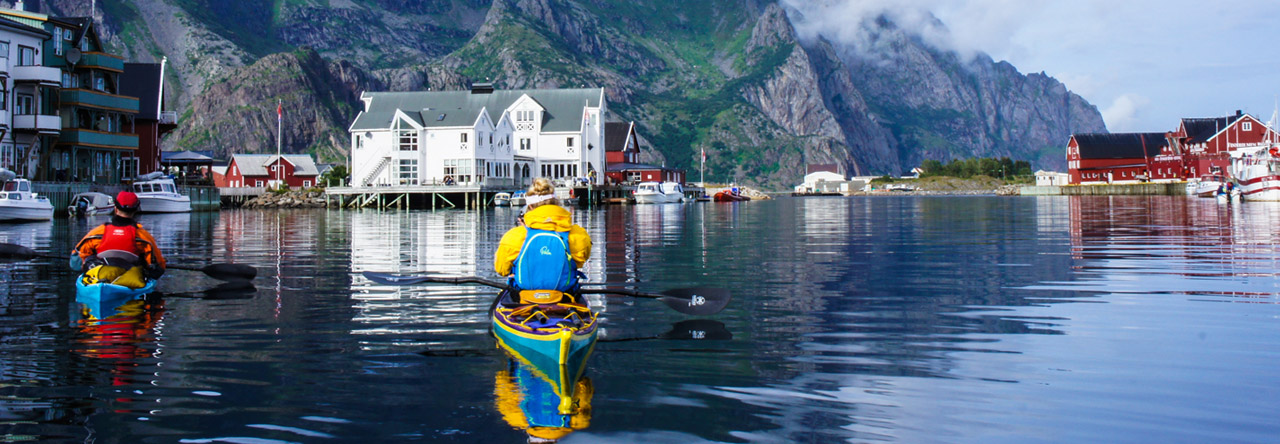
This Summer, my partner Amy and I headed over to British Columbia to paddle a section of the Inside Passage. If you’ve not heard of the ‘bucket-list’ worthy Inside Passage, it’s a coastal route that stretches 1700km from Washington, USA, through Western British Columbia, up to Skagway, Alaska. Its major drawcards being the teeming wildlife, a multitude of islands to weave, and the perfect balance of solitude versus opportunities to re-stock in remote First Nations communities.

We had a month to play with, so opted for a 780km section of this marine passage, from Comox on Vancouver Island up to Prince Rupert, in the north-west of British Columbia. We had a brilliant time encountering wildlife, meeting locals, and living the simple life, submersed in stunning scenery. This guide is intended to help you plan your Inside Passage adventure and hopefully provide a few nuggets of inspiration and lessons learnt.

When to go

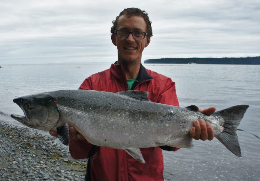
The climate is quite similar to Scotland, so expect rain and also stunning blue skies. We went mid-August to mid-September and paddled in t-shirts for 90% of the time. The great thing about Aug/Sept is the salmon are starting to run, so lots of Orca, Humpbacks, and the bears should be well fed (fingers crossed).

Where to go

Quick hit – The most compact enjoyment was certainly around Telegraph Cove. There are lots of guided trip options, amazing scenery, and loads of Orca and Humpback to get excited about.

For wildlife – The Broughton Islands certainly offered us the most varied scenery, tides, and wildlife. We saw about 60 Orca on separate occasions, Humpbacks galore, Sea Lions, Sea Otters, Bald Eagles, but no Bears…

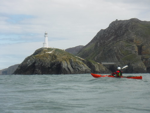
Wilderness – The further north we travelled, the fewer people we encountered. Although most of the coast has been logged at some point, north of Vancouver Island thick forest lines the high tide mark with only the occasional small village breaking the vista.

How to get there

Fly to Vancouver and catch either a bus and ferry over to Vancouver Island, or get a floatplane to your starting point from £50 upwards.

Boat hire

We found it surprisingly difficult to hire boats. MEC hire Scorpios from Vancouver City, but then you need to get them to your starting point. Most of the companies in the north of Vancouver Island only do guided trips. The best option we found was from a company called Comox Valley Kayaks. They hire out boats for any duration and provide a drop-off and pick-up service. We met other paddlers on shorter trips who used private boat shuttles to fine-tune their drop-off and pick-up points.

Maps

There are lots of marine charts and topographic maps available of the BC west coast. Depending on the length of your trip I’d recommend marine charts from 1:40,000 scale and smaller. As our trip was quite long and space was at a premium, we opted to use a road atlas for large scale planning and the Viewranger and Navionics apps for our day to day navigation. To charge our devices we had a 17 Watt, waterproof, Voltaic Systems solar panel and battery. This system worked amazingly well, enabling us to charge cameras, phones, VHF and head-torches.

Useful info

There is a ton of useful resources out there to help you plan your paddle. The Inside Passage Facebook Group is a great treasure trove of knowledge. We downloaded the book ‘Kayaking the Inside Passage’ by R.H. Miller onto our phones which offered information on history, tides, wildlife, routes, campsites, and much more. There are various online maps from previous paddling trips, featuring notated information such as campsites, water, and resupply points.

General conditions

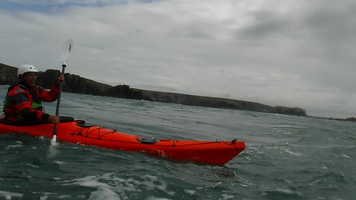
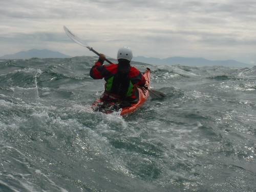
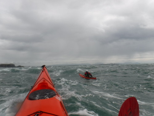
We found the paddling relatively straight forward. The majority of the route is sheltered by islands with only a few exposed headlands. The wind offered some challenges but was never a show stopper for us. However, we have heard from other paddlers that it gets much stronger & prohibiting. As a general rule of thumb, you could set your watch by winds picking up at 3 pm in the afternoon. Tides do get pretty strong in areas with overfalls and whirlpools so a good knowledge of tidal planning is vital. Lots of the tidal cruxes need to be paddled at slack water and it was often possible to paddle up tide by hugging the coastline. Landings are found quite regularly and we found many more campsites than recorded online or in Miller’s book. We carried up to 13l of water each and managed to fill up from taps with the back up of water purification means with us if necessary. Bears… We saw one from the water and heard another near camp whilst in our tent. Cook away from your tent spot where possible. Store all smellies in your hatches, seal them and flip your boat overnight. Get studious and read up on bear-safe camping. Again, not a show stopper, but we have heard of trips earlier in the year with a greater number of sightings & encounters.

This area really is a sea kayaker’s paradise, with something for everyone. If you are thinking about a trip out there, do it! Give me a shout if you would like to chat more about it, and happy paddling.

Sea Kayak Training Camp 2019

With the success of the SKTC of last year it became clear that there certainly would be another chapter in this story. We were asked again to coach this training camp a second time. Of course, we joined in, to share our passion and knowledge with other sea kayak enthusiasts. The advantage of this SKTC is that everyone can join and that we can start with basic things in a calm and beautiful environment with low risks. That way it’s possible to give a very personal approach what was very much appreciated by the participants. Safety and making fun are key in the program, if there is no smile on your face, then there must be something wrong. The camp takes places over five days with both theoretic lessons and a lot of practice on the water. We start with basic things and then move over to combined exercises and even worst-case scenarios where the participants must solve the problem. Working as a team is equally important, the first day we immediately said that we don’t want a group, but a team! I want to thank the team members for their positive spirit during the camp, my assistant Winoc to be at my side during coaching and Boris & Ivka from http://spiritofkorkyra.com/ for again a perfect organisation. Let us not forget NSK team member Sylvie! Without her it would not been possible to make this video, she spends hours on the beach to take a lot of footage…. Maybe we will see you next year? Paddle safe and take care of each other!

Destination Guide – Lofoten

Lofoten really is a sea kayakers paradise.  It combines Scotland’s intricate west coast with the mountain scapes of Patagonia and the wildlife of an Attenborough episode to create a truly magical place.  This summer Amy Dunis and I spent a month exploring this archipelago and have put together a destination guide to inspire and help you head out to enjoy these islands as much as we did.

Different places to paddle

Henningsvær – Is called the “Little Venice” of Lofoten.  You can explore and fish around the surrounding islands, then paddle into the spectacular harbor that cuts right through the picturesque town.

Moskenesøya – Is an amazing island in the south of the Archipelago that is the definition of wilderness.  Towering cliffs, soaring sea eagles, endless beaches. This is the place to go to get away from it all.

Trolltindan mountains – Towering peaks, hanging glaciers, smooth granite faces and lush green fields dotted with grass roofed huts.  A circumnavigation of this area gives you a real taste for all that is good about Lofoten.

Must sees

1. Sea eagles are by far the coolest looking bird out in Norway.  With a wingspan of up to 240cm they keep watch from cliffy headlands and saw overhead with such grace.  On our best day we spotted 11 birds with each sighting as exciting as the last.

2. Trollfjord is the crème de la crème of fjords.  1100m peaks drop straight into the 100m wide Fjord with snow capped mountains surrounding you.  Our top tip would be to get there early before all of the noisy tour ribs arrive.

3. Rulten in the Trolltindan mountain range claims the title of “Lofotens most beautiful mountain”. Paddling in crystal blue waters beneath the peak with a pristine grass roofed hut in the foreground sums up the Lofoten landscape perfectly.

4. Renei Fjord is a stunning 3 pronged fjord that cuts deep into the Moskenesøya mountains.  It is the perfect place to paddle when the open seas are wild and a great place to explore if you are new to sea kayaking.

5. Moskenesøya beaches are by far the best in Lofoten. They are plentiful and their white sands stretch for miles.  Camped up, with a fire roaring and the sun setting is pretty hard to beat.

When to go

The climate is similar to Scotland but on average 4°C colder so the best time to go is June to August.  This also allows you to experience the amazing 24h daylight.  Prepare to experience rain and wind but you will have the best chance to experience that classic Lofoten sun.

How to get there

This depends on your trip duration, budget and how many podcasts you have.  We chose to drive as we wanted to take our boats, lots of food and not have to hire a car.  It was a 47h drive so not for the fainthearted or those with limited time.  Another option is to fly to Tromso and then transfer to Lofoten by either bus, express boat, plane or onboard the Hurtigruten (ferry).  A hire car would make life a lot easier but isn’t essential.


Boat hire

Reine Adventure in the south and Lofoten Aktiv AS in the North hire boats and gear but you must have evidence of being at least BC 3*.  Both companies will be able to give you some great advice on where to go with the forecasted weather.

Where to stay

Wild camping opportunities in Norway are amazing.  You can camp for up to two nights anywhere on uncultivated land as long as you are over 150m from an inhabited building.  This is a great way to save money and also wake up in truly amazing places. There are plenty of campsites with good facilities and hotels if you are feeling fancy.

Guidebook

Yann Engstad and Olly Saunders have produced a brilliant guide to the Lofoten islands with loads of brilliant day trips to do and a detailed explanation of the outer coast for those seeking to circumnavigate some or all of these magical islands.

Thanks to P&H for the use of the brilliant Scorpios 🙂

If you would like any more information about paddling or climbing in these magical islands please get in touch – Highland Kayak School.

The North Sea Crossing 2018

After my previous record back in 2015, I had no idea that I would go for a second attempt, but the past year the sea began to call again.

I waited together with a Spanish team last year (2017) on perfect weather, with no success.  It was only this summer, after waiting a few months, that I saw an opportunity.

I had also contact with Eddie and Jens, a German team that had the ambition to attempt to cross the North Sea. We shared information and knowledge.  We agreed to stay in contact and start together if possible.  They would make the same trajectory as I did in 2015.

So, we got together during the night in Nieuwpoort harbour on Wednesday 1st of August 2018. Both the German team and I had made practically the same navigational planning and we wished each other success.  I must say that it was an honour to depart together with them.  I said goodbye to my wife and children.  My wife Sylvie is my support team and keeps keep contact with Oostende Radio on the Belgian side, and Dover Coast Guard on the UK side.  Both services were informed properly about our intentions.

At 01 o’clock (local time), I started from the slipway at Nieuwpoort harbour, Belgium. I had some light from the full moon.  I started at a pace I could keep up for hours without stopping or resting.  When I left the safety of the harbour, all stress was away, I felt alive!  Although it was too dark to see a thing, I knew my way around.  This first part was a home run in my backyard so to speak.  I chose to leave at this hour because of the tidal stream.  I wanted the stream against me during the first six hours.  I rather have it along the Belgian coast where it less powerful (but not to be mistaken) than on the UK side, where it is almost double the speed.  I passed the Trapegeer buoy when the stream was still building up against me.  Between here and the next buoy, the DY1, is a real battle.  A battle against the tide, a battle against a shortage of sleep, and I must be alert for other ships who couldn’t see me.  During the night I had only a force 2 headwind.  I was relentlessly pushed back by the tidal stream and the wind during the very short breaks.  One of the things I enjoyed most was sunrise.  I took a very short break at that moment, so I could see the sun coming up.

When I finally arrived at the DY1 buoy it was almost slack water. Taking it easy now is not an option, since I need this advantage badly to reach the final section in time (also tidal stream related).  From the DY1 buoy, I hopped to the SE Ruytingen buoy and finally the NW Ruytingen buoy, where the international shipping lane starts.  I was there a bit too soon.  I set course to the WSW Sandettie buoy.  I saw that my speed was decreasing very much due to the stream that was still heading SW.  Soon I took the decision to deviate the planned route and head towards the Sandettie lightship.  The downside was that I crossed this part of the shipping lane at a sloping angle instead of as straight as possible.  I had no other choice, because my speed was almost gone too, which makes a straight crossing of the shipping lane in this case even more dangerous.  So, to the lightship it was!  Except for one sailing vessel, I did not pass any professional shipping on this section.  My speed increased and so I could take all the benefit I needed to go on.

When reaching the Sandettie lightship I was excited. I always had an interest in ships, beacons, buoys, and now this one was ticked off on my list.  The second thing I was excited about was that I could now see the white cliffs of Dover in the distance. The next buoy, SW Sandettie, was close and so was the second part of the shipping lane.  I was able to cross it straighter.  During the crossing of the shipping lane, I only saw two merchant ships, that was all.  Leaving the shipping lane behind it set course to the Goodwin lightship.  Also, not on my initial plan, but since I deviated I had to adapt.  There was very little tidal stream during this part, I could reach it without compensating a lot.  It was slack water, but a bit choppy due to the area I’m in, the Goodwin Sands.  I took a last break and I made a call with the VHF to the Dover Coast Guard to state my position and status.  In turn, they informed my wife (aka, the support team).

I knew from the previous time that the last section should be worse now due to the wind. The wind was increasing to force 3-4 from the side (WSW) and the current would soon pick up in the northerly direction.  So, I started heading to the harbour of Ramsgate, which I could not see at this point.  The waves were there all the time from this point on, due to the current pushing over the Goodwin Sands and the wind.  It decreases the much-needed speed to aim for the harbour.  The more I closed in on land, the harder the tidal stream was pushing from the port side.  With a lot of persistence, I reached Ramsgate harbour, finally!!  My wife and two children were there, waving and yelling.  I was relieved, happy, excited, exhausted and had a feeling that I could take on the whole world while being so tired that I could capsize in the blink of an eye, all at the same time.  Just to be correct, after greeting my family, I paddled on to the slipway.  It was only there that I switched off my GPS.  I had paddled 107 kilometres and spent 17hours and 48minutes doing so.  After taking a shower and eating a hot meal, we went back home by ferry.

My first time in 2015 was perfect, the weather was perfect, the sea was flat. This time the weather was good…  only good, not perfect. No kayaker talks about force 3 or 4 unless you’re on a mission like this one.  I could adapt, as I’m usually doing.  But the constant headwind in the first half and the portside wind on the last section took their toll.  I have no regrets, but I made it more difficult by crossing during these conditions.  Make no mistake, the sea is boss, you’re not.  Even with a lot of training and preparation, it’s the sea that will decide whether you’re ready for it, or not.

I wish to thank my family from all my heart for their continuously and unconditional support on all that I do or undertake! Were it not for them, I would not have done this.  Thank you, thank you!

Special thanks to the people from Ostend Radio (MRCC Oostende-Belgian Coast Guard) and Dover Coast Guard (UK) for virtually watching over me during the crossing, again!

The specifications:

Sea kayak: P&H Cetus MV (Expedition Kevlar/Carbon)

Paddles: VE Explorer (medium blades + spare paddle)

Full safety gear including VHF radio, PLB, pyrotechnical flare, ODEO flare, mobile phone, first aid kit, repair kit, paddle-float, pump…

The video report of this crossing:


Paddle safe and take care of each other on the water!

Dimitri Vandepoele

The Recap #2

In the Recap series we share our best cut scenes, experiences and other footage. If we can share the vibe with others and make other people longing to go out with a sea kayak on the water, than our mission has succeeded! 🙂 If you are not a sea kayaker already, maybe now is the time? There’s a wide range of things you can do with this craft, and some training. Most important of all, it’s all about the smiles and the companionship! Enjoy!


The Locks

We must be a bit resourceful over here. It is not because we don’t have tidal races over here along the Belgian coast that we cannot train on breaking in and out of one.  Somewhere in the back of Nieuwpoort harbor there is a complex with different locks called the Ganzepoot (goose foot, because it looks like one when seen from the air).  In the periods with heavy rain there is too much water in the five adjacent canals and in the river Yser.  The locks are then opened a few hours before low tide, until a few hours after.  The amount of water that comes like an unstoppable force trough the locks is phenomenal.  It also makes a perfect practicing area for us, sea kayakers.  The different canals and locks have their own characteristics.  We always start our training on the slower flowing water, and then build up until we go on the Yser lock.  The Yser lock releases the most amount of water, at the highest speed.  We train on breaking in, and back out, of fast moving water.  You need a good angle of approach, some speed and a good lean-brace position.

The Westhinder Challenge

We are always looking for a good challenge, preferably one that takes us offshore. If you look at the Belgian part of the North Sea, there are no islands that you can paddle to (with the exception of the North Sea crossing to the UK). We have to do it with our buoys, navigation marks and towers. Yes, there are towers located in the Southern part of the North Sea. Two of them are drawing our attention. The first, and closest one, is the Oostdyck radar tower. When visibility is extremely well, it can be seen from the beach without binoculars. The radar sends all shipping movements to the Traffic Centre for monitoring. This tower is located some 21 kilometres offshore. What cannot be seen from ashore is the second tower located at the Westhinder sandbank. This one lies just behind the international shipping lane, one of the busiest in the world. The Westhinder beacon warns ships for the danger of the sandbank beneath. It also monitors the force of the wind and direction, which is important for the weather forecasts for this area. This tower is located some 32 kilometres offshore.
To take on this challenge you’re not only need a good physical condition and stamina, you also have to know more than basic navigation. There is always a strong tidal stream that pushes you constantly off track, the stream is never in you favour. Taking a break, even a short one, relentlessly pushes you off track. Also the strength of the tidal stream changes every hour, so you have to keep a good eye to your bearings. During the most of the challenge, you will not have any reference to paddle to. When you reach the first tower, you still have to cross the international shipping lane, which is one of the busiest in the world. Keep in mind that those very large ocean ships probably want see you, or change their course or speed for a sea kayaker. When you crossed the shipping lane and finally reach the Westhinder beacon, then you just completed the first half of the challenge. The second half, and the most important one, is to get yourself and your team back to shore safely. If you’re tired, you can’t just quit. There is no support boat to help you. There is only you and your team.
I’m proud to say that were able to put together a small international team to take on this challenge. Two very experienced and well trained Spanish sea kayakers were eager to take on this challenge. They travelled all from Spain to Belgium, we spend some days paddling together, before heading out. On Saturday 7 July 2017 we started from the Oostduinkerke beach, at 07:40 am (local time). As an extra difficulty we chose to navigate on compass, with a sea chart. We carried also a GPS, just for registration and safety precautions, not for navigation. We stated our intentions to the Coast Guard by radio before the start. We paddled at a high pace, in order to compensate a bit lesser for the sideways tidal stream. In the video you can see the buoys that we have passed, the way we have taken on this challenge. It took us seven hours to reach the Westhinder beacon. When we got there we established radio contact with the Coast Guard again, to tell them our position and that we were still in good shape to commence the way back to shore. It was 14:30 pm (local time) and we were at the farthest offshore point, being 32 kilometres. When arriving there, perhaps euphoric, we just did half the challenge. The second part, also the hardest, was to get back with the team. It’s also a psychological battle because you have absolutely nothing to look to, there are no references, and you cannot see the land for hours. The visibility was limited to ten kilometres, which is normal for us. You have to trust your navigation skills, simple as that. Even when tired, we still kept the same high pace to counter the current. We arrived back at Oostduinkerke beach at 20:55 pm (local time).
In the video you can see our GPS track log. The GPS was not turned off during our short breaks. It registered all of our movements during the challenge.
To all other sea kayakers out there who are looking for a tough challenge, this could be what you are looking for. Be well prepared for this one, both physically, mentally and be sure of you navigation skills.
I got extremely lucky to do this one with such experienced sea kayakers! Big thanks to Carlos GARCIA and Santi DOMINGUEZ for joining! It was an honour to be part of this team, and to beat this challenge together!  Check out this unique record on the Performance Sea Kayak website; http://www.performanceseakayak.co.uk/Pages/Records/Uniques/recordsUniques.php

The Trip

When we got a first email from Will and Beverly, from the North Skye Kayak Club in Scotland, we never imagined that we would have that much in common. They asked if they could join us on our training sessions along the Belgian coast to see how we are doing things, and also to meet the NORTHSEAKAYAK-team. We think that Scotland has sent out their most friendliest inhabitants, there was immediately a good connection between us! Upon their arrival in Belgium we chose to do a variety of training sessions in the four days of their stay. On the first day, we did an offshore trip to the marine farm in front of Nieuwpoort. We combined that with some rescue exercises along the way. The second and third day we did a typical “harbour-training” in Nieuwpoort. It’s a perfect venue to teach/learn a variety of skills. We did balance exercises, trained on self-rescue and assisted rescue techniques. With all the palisades, docks, mooring stations and boats it also makes a good spot to train on boat-control . We use them to paddle around in order to train the different steering strokes while being in a safe environment. We saved the best for last, the fourth and last day we had perfect surfing conditions. The swell was good, and the waves steep but not too high. We gave an explanation on the behaviour of the waves, the wave sets and how to paddle trough the surf and back. Being on a wave, gaining speed and rushing back to the beach is one of the most exciting things you can do with a sea kayak. We think that those smiles we got during the visit of our Scottish friends will stay on for a longer period of time. We hope to visit them in the future, on the beautiful Isle of Skye!!

Anglesey Stacks trip with P&H dealer Manu Redureau

On Sunday 27 August P&H dealer Manu Redureau, of Bekayak, Brest, France, joined me for a blast around the Stacks.  This trip also gave Manu the opportunity to try out the Delphin MKII Corelite X in rough water conditions.

Our journey took us from Porth Dafarch to North Stack and back – similar to the route shown below from the ‘Welsh Sea Kayaking: Fifty Great Sea Kayak Voyages’ book.  We enjoyed surf and rough water at Penrhyn Mawr, followed by some small surf at South Stack before lunch on the rocks in Gogarth Bay – the seal pupping season from August to November precluded us from using the beaches.  After lunch we returned to Porth Dafarch by closely following the coastline and exploring lots of channels, arches, caves and rock gardens.  The journey was both fun and a great work out.  Thanks for a great day out Manu!

Geth Roberts, www.seakayakingwales.com

Penrhyn Mawr

DSCF5338

DSCF5333

DSCF5335

DSCF5330

DSCF5367

South Stack

DSCF5384

DSCF5398

DSCF5403

Wen Zawn and Cathedral Arch

DSCF5425

A smaller Gogarth Bay arch

DSCF5446

DSCF5448

DSCF5455

Below Elen’s Castle

DSCF5458

DSCF5466

DSCF5479

Abraham’s Bosom

DSCF5501

The Lightpainting Job – Part III

For the third and probably the last time I was asked by the Cervo Go photographers team to join in on a so called light painting session. We made arrangements with instructor Fanny, for a meeting with her team at Nieuwpoort harbour. Light painting is photographing a moving light with a longer shutter time; the effect is a long, bright line in one picture. The camera has to be positioned on a tripod because it may not move, not even a bit. This year the challenge was to get the kayaker also in the picture, the use of the camera flash makes this possible. Several try outs were made just before dark, just to get thing perfectly right. Trajectory, distance and communication were key to allow the photographers to make their perfect photo. There was a light strip attached to the paddle, which makes those graceful and colourful lines in the photos. The video shows the setup and how it is done, at the end there are a few pictures included, just to show the result of the hard work. Again, it was a true pleasure to work with passionate people. It is really great to see the result of the cooperation between photographer and sea kayaker.


Page 3 of 77

Powered by WordPress & Theme by Anders Norén