Sea Kayaking Articles from P&H Staff, Team Paddlers, and Friends

Month: September 2018

Destination Guide – Lofoten

Lofoten really is a sea kayakers paradise.  It combines Scotland’s intricate west coast with the mountain scapes of Patagonia and the wildlife of an Attenborough episode to create a truly magical place.  This summer Amy Dunis and I spent a month exploring this archipelago and have put together a destination guide to inspire and help you head out to enjoy these islands as much as we did.

Different places to paddle

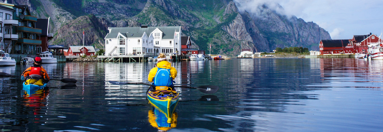
Henningsvær – Is called the “Little Venice” of Lofoten.  You can explore and fish around the surrounding islands, then paddle into the spectacular harbor that cuts right through the picturesque town.

Moskenesøya – Is an amazing island in the south of the Archipelago that is the definition of wilderness.  Towering cliffs, soaring sea eagles, endless beaches. This is the place to go to get away from it all.

Trolltindan mountains – Towering peaks, hanging glaciers, smooth granite faces and lush green fields dotted with grass roofed huts.  A circumnavigation of this area gives you a real taste for all that is good about Lofoten.

Must sees

1. Sea eagles are by far the coolest looking bird out in Norway.  With a wingspan of up to 240cm they keep watch from cliffy headlands and saw overhead with such grace.  On our best day we spotted 11 birds with each sighting as exciting as the last.

2. Trollfjord is the crème de la crème of fjords.  1100m peaks drop straight into the 100m wide Fjord with snow capped mountains surrounding you.  Our top tip would be to get there early before all of the noisy tour ribs arrive.

3. Rulten in the Trolltindan mountain range claims the title of “Lofotens most beautiful mountain”. Paddling in crystal blue waters beneath the peak with a pristine grass roofed hut in the foreground sums up the Lofoten landscape perfectly.

4. Renei Fjord is a stunning 3 pronged fjord that cuts deep into the Moskenesøya mountains.  It is the perfect place to paddle when the open seas are wild and a great place to explore if you are new to sea kayaking.

5. Moskenesøya beaches are by far the best in Lofoten. They are plentiful and their white sands stretch for miles.  Camped up, with a fire roaring and the sun setting is pretty hard to beat.

When to go

The climate is similar to Scotland but on average 4°C colder so the best time to go is June to August.  This also allows you to experience the amazing 24h daylight.  Prepare to experience rain and wind but you will have the best chance to experience that classic Lofoten sun.

How to get there

This depends on your trip duration, budget and how many podcasts you have.  We chose to drive as we wanted to take our boats, lots of food and not have to hire a car.  It was a 47h drive so not for the fainthearted or those with limited time.  Another option is to fly to Tromso and then transfer to Lofoten by either bus, express boat, plane or onboard the Hurtigruten (ferry).  A hire car would make life a lot easier but isn’t essential.


Boat hire

Reine Adventure in the south and Lofoten Aktiv AS in the North hire boats and gear but you must have evidence of being at least BC 3*.  Both companies will be able to give you some great advice on where to go with the forecasted weather.

Where to stay

Wild camping opportunities in Norway are amazing.  You can camp for up to two nights anywhere on uncultivated land as long as you are over 150m from an inhabited building.  This is a great way to save money and also wake up in truly amazing places. There are plenty of campsites with good facilities and hotels if you are feeling fancy.

Guidebook

Yann Engstad and Olly Saunders have produced a brilliant guide to the Lofoten islands with loads of brilliant day trips to do and a detailed explanation of the outer coast for those seeking to circumnavigate some or all of these magical islands.

Thanks to P&H for the use of the brilliant Scorpios 🙂

If you would like any more information about paddling or climbing in these magical islands please get in touch – Highland Kayak School.

The North Sea Crossing 2018

After my previous record back in 2015, I had no idea that I would go for a second attempt, but the past year the sea began to call again.

I waited together with a Spanish team last year (2017) on perfect weather, with no success.  It was only this summer, after waiting a few months, that I saw an opportunity.

I had also contact with Eddie and Jens, a German team that had the ambition to attempt to cross the North Sea. We shared information and knowledge.  We agreed to stay in contact and start together if possible.  They would make the same trajectory as I did in 2015.

So, we got together during the night in Nieuwpoort harbour on Wednesday 1st of August 2018. Both the German team and I had made practically the same navigational planning and we wished each other success.  I must say that it was an honour to depart together with them.  I said goodbye to my wife and children.  My wife Sylvie is my support team and keeps keep contact with Oostende Radio on the Belgian side, and Dover Coast Guard on the UK side.  Both services were informed properly about our intentions.

At 01 o’clock (local time), I started from the slipway at Nieuwpoort harbour, Belgium. I had some light from the full moon.  I started at a pace I could keep up for hours without stopping or resting.  When I left the safety of the harbour, all stress was away, I felt alive!  Although it was too dark to see a thing, I knew my way around.  This first part was a home run in my backyard so to speak.  I chose to leave at this hour because of the tidal stream.  I wanted the stream against me during the first six hours.  I rather have it along the Belgian coast where it less powerful (but not to be mistaken) than on the UK side, where it is almost double the speed.  I passed the Trapegeer buoy when the stream was still building up against me.  Between here and the next buoy, the DY1, is a real battle.  A battle against the tide, a battle against a shortage of sleep, and I must be alert for other ships who couldn’t see me.  During the night I had only a force 2 headwind.  I was relentlessly pushed back by the tidal stream and the wind during the very short breaks.  One of the things I enjoyed most was sunrise.  I took a very short break at that moment, so I could see the sun coming up.

When I finally arrived at the DY1 buoy it was almost slack water. Taking it easy now is not an option, since I need this advantage badly to reach the final section in time (also tidal stream related).  From the DY1 buoy, I hopped to the SE Ruytingen buoy and finally the NW Ruytingen buoy, where the international shipping lane starts.  I was there a bit too soon.  I set course to the WSW Sandettie buoy.  I saw that my speed was decreasing very much due to the stream that was still heading SW.  Soon I took the decision to deviate the planned route and head towards the Sandettie lightship.  The downside was that I crossed this part of the shipping lane at a sloping angle instead of as straight as possible.  I had no other choice, because my speed was almost gone too, which makes a straight crossing of the shipping lane in this case even more dangerous.  So, to the lightship it was!  Except for one sailing vessel, I did not pass any professional shipping on this section.  My speed increased and so I could take all the benefit I needed to go on.

When reaching the Sandettie lightship I was excited. I always had an interest in ships, beacons, buoys, and now this one was ticked off on my list.  The second thing I was excited about was that I could now see the white cliffs of Dover in the distance. The next buoy, SW Sandettie, was close and so was the second part of the shipping lane.  I was able to cross it straighter.  During the crossing of the shipping lane, I only saw two merchant ships, that was all.  Leaving the shipping lane behind it set course to the Goodwin lightship.  Also, not on my initial plan, but since I deviated I had to adapt.  There was very little tidal stream during this part, I could reach it without compensating a lot.  It was slack water, but a bit choppy due to the area I’m in, the Goodwin Sands.  I took a last break and I made a call with the VHF to the Dover Coast Guard to state my position and status.  In turn, they informed my wife (aka, the support team).

I knew from the previous time that the last section should be worse now due to the wind. The wind was increasing to force 3-4 from the side (WSW) and the current would soon pick up in the northerly direction.  So, I started heading to the harbour of Ramsgate, which I could not see at this point.  The waves were there all the time from this point on, due to the current pushing over the Goodwin Sands and the wind.  It decreases the much-needed speed to aim for the harbour.  The more I closed in on land, the harder the tidal stream was pushing from the port side.  With a lot of persistence, I reached Ramsgate harbour, finally!!  My wife and two children were there, waving and yelling.  I was relieved, happy, excited, exhausted and had a feeling that I could take on the whole world while being so tired that I could capsize in the blink of an eye, all at the same time.  Just to be correct, after greeting my family, I paddled on to the slipway.  It was only there that I switched off my GPS.  I had paddled 107 kilometres and spent 17hours and 48minutes doing so.  After taking a shower and eating a hot meal, we went back home by ferry.

My first time in 2015 was perfect, the weather was perfect, the sea was flat. This time the weather was good…  only good, not perfect. No kayaker talks about force 3 or 4 unless you’re on a mission like this one.  I could adapt, as I’m usually doing.  But the constant headwind in the first half and the portside wind on the last section took their toll.  I have no regrets, but I made it more difficult by crossing during these conditions.  Make no mistake, the sea is boss, you’re not.  Even with a lot of training and preparation, it’s the sea that will decide whether you’re ready for it, or not.

I wish to thank my family from all my heart for their continuously and unconditional support on all that I do or undertake! Were it not for them, I would not have done this.  Thank you, thank you!

Special thanks to the people from Ostend Radio (MRCC Oostende-Belgian Coast Guard) and Dover Coast Guard (UK) for virtually watching over me during the crossing, again!

The specifications:

Sea kayak: P&H Cetus MV (Expedition Kevlar/Carbon)

Paddles: VE Explorer (medium blades + spare paddle)

Full safety gear including VHF radio, PLB, pyrotechnical flare, ODEO flare, mobile phone, first aid kit, repair kit, paddle-float, pump…

The video report of this crossing:


Paddle safe and take care of each other on the water!

Dimitri Vandepoele

Powered by WordPress & Theme by Anders Norén