Sea Kayaking Articles from P&H Staff, Team Paddlers, and Friends

Author: P And H Sea Kayaks Page 1 of 2

Hammer – Reveiw from the Woodmill Sea Symposium

Woodmill Sea Symposium 6-7th July, 2013.

Test report: P&H Hammer.

I’ve been going to the Woodmill Sea Symposium ever since the first one three years ago. Being fortunate enough to work there as a volunteer coach also means I get to try out the centre’s demo fleet.

However, it’s always nice to see P & H come to visit us so you can see what their latest offerings are. Even better when you can have a paddle of it and put a boat through it’s paces.

Despite arriving early for trip leader & back up coach briefing I managed to find myself looking short changed on the boat front. Our trip leader Pete Brown had jokingly replied that I could always paddle around Hayling Island (our particular trip ) in a Burn!? Many a true word spoken in jest it seemed. I went over to the P & H rep Jim Pearce who kindly stepped in & pointed to a new “ Hammer”.  I looked over to a yellow/ mustard coloured boat that looked like someone had taken a Burn stretched it, added hatches, deck lines & a skeg & then put a Connect system in for good measure.

hammer_top_lava72

So what’s it like? Well actually very comfortable, stable & tracks quite well without using the skeg. The kayak itself has a fairly pronounced rocker at the front; not unlike a river runner. The bow is softly rounded & you could be forgiven for thinking you were looking at a white water kayak. Following back towards the cockpit the manufacturers have thoughtfully put two recesses for resting the ends of your split paddles into. A little further on is a forward hatch with more than enough space to store a fair amount of kit. The deck elastics continue on before you arrive at the cockpit. I found that the deck elastics were ample enough to keep a tight grip on my splits & still hold my pump & water bottle. The cockpit is a keyhole shape & I found that my keyhole size spray deck fitted on comfortably without the usual dramas you sometimes get with stretching your deck over. The seat is a standard Pyranha type with the connect system for ratcheting up the tension on the back rest & ensuring a snug fit into the thigh braces. A white water type footplate with the alloy runners & plastic nuts for adjustment is there for giving your feet something to brace against.

hammer_side_lava72

Behind you is a day hatch; with loads of space more deck elastics & then another hatch for gear stowage. Interestingly the fore & aft have been fitted with river boat type grab handles as well as the toggle grip on the ends that you would expect to find on sea kayaks. Top marks to P & H on this one as it certainly made portages up & down the beach easier. The hull is a planning type with a skeg recess towards the rear. Again the end of the hull here has been given rocker but in a more subtle way.

I have to be honest & say that initially I was privately having a few misgivings as seeing that everyone else was in a traditional style sea boat I realised that I was probably going to have my work cut out keeping up. I also got a few little off the cuff remarks about my new sea kayak playboat!

Well I’m always up for a challenge to try something new & the old adage about not judging a book by it’s cover is ever true. The Hammer did not disappoint. I was told by Jim the P & H rep that what the Hammer had been designed for was rock hopping, playing in the surf & for being able to get in & out of caves without the usual reverse in or trying to swing the boat around in a confined space with water that may be falling & rising with the swell.

Photo courtesy of Karl Midlane.

Photo courtesy of Karl Midlane.


First impressions? This is a comfortable boat that you could put a reasonable amount of distance in without the usual little niggles or cramps that I’ve had with other manufacturer’s boats. You could do a day trip in this boat with long periods before you had to get out & stretch your legs. On launching through a gentle swell I found the Hammer to be very stable with none of the slight twitchiness that some sea kayaks have. This includes following along the coast with a beam on sea; a situation that for some novices is not always comfortable to be in.

The weather for the trip could not have been better.  There was a gentle swell off the coast where we launched & virtually no breeze. Interestingly I noticed that my cadence rate for paddling was no greater than that of my fellow paddlers. I’ve usually found that experience has shown me that if I’m not comfortable in a boat I usually know within the first thirty minutes or so. At this point I was still comfortable & enjoying the Hammer. On entering the harbour mouth to Langstone the usual squadron of jet skiers & holiday boaters were there to meet us with varying degrees of wash to play on. I was now starting to see what the Hammer was all about as I gleefully bounced over the first wave to execute a low brace turn with a surprising turn of speed for a longer boat. Images of surfing larger waves & pulling off surfing type tricks were starting to form in my mind. No such luck in Langstone harbour! But you can’t have everything. The kayak edges & turns easily & would give confidence & comfort to the beginner.

Another hour or so of paddling placid water, albeit with a slight tidal flow working against us didn’t seem to be causing me to work harder than anyone else. In fact the ability to turn quickly in this kayak is an advantage when you have novice paddlers with you & may have to effect a prompt rescue. This didn’t get put to the test on the day, but I got the impression that the Hammers stability would make it ideal for this task.

I swapped with Jim after the lunch break as he hadn’t paddled it before & he wanted to test the Hammer for himself. Somewhat regretfully I found myself paddling Jim’s Cetus MV; a boat which I do like. I’d paddled the Hammer for half of the trips 22km & was pleasantly surprised with it’s abilities & comfort.

Making our way through Chichester harbour back towards the open sea I noticed that Jim was having no trouble keeping up with the group. When we found a nice big sandbar with breaking waves to play on & I watched Jim surf on the wave & then pull off turns on the downward face with such ease, I was envious. Don’t get me wrong I was also having a great time in the Cetus, but you need greater input to achieve the same effects on the wave.

This is the sort of situation where the Hammer comes into it’s own. For me this would make a great day trip boat with the ability to keep up with the pack for the shorter distances. I wouldn’t see myself doing long open water crossings or week long expeditions maybe; but a couple of days wouldn’t be a problem with the roominess of the hatches fore & aft makes short trips a possibility. This would also make a good boat to put a novice sea kayaker in to build confidence & ability. Another thought was as a coaching boat when out with absolute beginners because of it’s swift turning abilities. Unfortunately I have had nothing else to compare the Hammer against as a bench mark for comparison purposes. Possibly because it’s quite unique within the sea kayak world; the nearest comparison I could come up with would be the Rockhopper made by RTM.

Photo courtesy of Ben Lawry

Like all things in life it’s horses for courses. If you can afford a traditional sea kayak as well as the Hammer for playing in then you’ve got the best of both worlds. However, if you don’t want to do multi day expeditions, but do a couple of days away, still keep up with your mates, but have the advantage of quick manoverabilty when it’s playtime out on the sea, then the Hammer may just be what you’re looking for. I was certainly impressed & if funds allowed I would buy one.

Pete Sarginson – Volunteer Coach at Woodmill Outdoor Activity centre.


Aries 155 – Review by Olly Sanders

A review of the Aries after a years coaching and playing with Olly Sanders.

The Mississippi Challenge 2013 – May Madness

The next instalment from Sam and the Mississippi Team who set off on June 5th.
Find them on Face book HERE
And the web HERE


2012 Missouri-Mississippi River – Source to Sea paddling descent

Distance:  3780 miles / 6083 kilometres
Duration:  117 days (11.06.2012 – 05.10.2012)
Kayak:  P & H Scorpio 170

The 7 rivers 7 continents project is a multi-year undertaking to make paddling descents of the longest river on each continent. 22 000 miles in total.

Amazon River(South America) – 6937 km (4300 miles) – completed 2007/2008

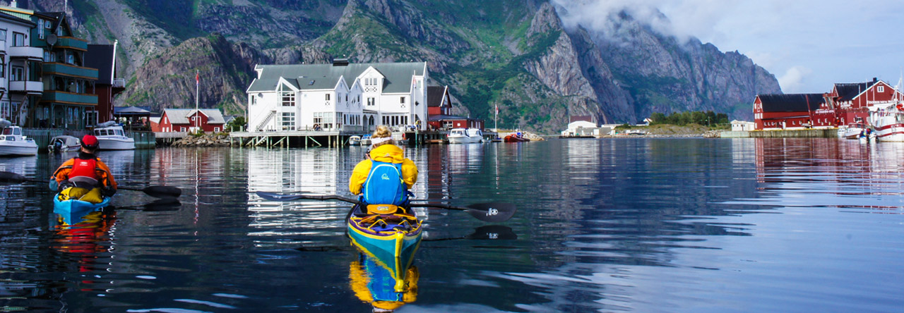
Missouri- Mississippi River (North America) – 6083 km (3780 miles) – completed 2012

Nile River(Africa) – 6650 km (4132 miles)

Yangtze River(Asia) – 6300 km (3916 miles)

Volga River(Europe) – 3645 km (2266 miles)

Murray-Darling River(Australia) – 3370 km (2904 miles)

Onyx River(Antarctica) – 40 km (25 miles)

My descent of North America’s longest river system, the Missouri-Mississippi River took 117 days paddling 3780 miles across the USA.  The descent began at the river’s utmost source, Brower’s Spring in Montana’s Centennial Mountains.  The spring lies at an altitude of approximately 2680m above sea level.  In early June when I began my descent the spring was still covered by at least 1.5 metres of snow.  

On the 11th June I set off from my established base camp amongst the dense pine trees towards the spring.  I followed the upper most waterway known as Hell Roaring Creek; a steep narrow creek as closely as possible.  After 5 hours of ascent I was forced on to snow shoes. In my hand I carried bear spray and called out to bears till my voice became hoarse.  Finally, following 7 hours of hard uphill slog I reached the spring.  Waypoint marked, images recorded, my descent could begin.

For several hours, Hell Roaring Creek alternately ran free and was covered by old snow and ice.  At this time, impossible to run.  Too much snow and not enough water.  After another 5 hours of descent I stumbled exhausted into my camp, day 1 over.


Hell Roaring Creek runs out of steep sided canyon into a wide, flat valley floor. Still too shallow to kayak I would follow the creek for 22 miles on foot as it flowed into Upper and Lower Red Rock Lakes, closed at this time of year to paddling in order to protect nesting birds.  Still with bear spray in hand, moose, deer, eagles and other birds were to be found.  

As I passed the wildlife refuge office I arranged with the manager, Bill West to transport my kayak from my camp to the outlet of the lower lake.  Bill was happy to do so and in his pickup we explored the refuge on the way to collect the boat.  Bill dropped my kayak off and deposited me back at the office in order that I might not break my human-powered  journey.  With the sun setting I marched out the final 4 miles to my boat.  Bill had told me to keep an eye out for a wolf pack in the area.  Sure enough at dinner that evening they showed up, with little fear of my headlamp and yelling.  Bigger and much more bold than coyotes they watched a while before disappearing into the night.


At dawn the next day I packed my kayak and slid into the water.  Finally I was paddling.  The Red Rock River flowed slowly and meandered like a lazy snake.  Sometimes deep enough, though often I dragged my boat across a rocky bottom.  The small river flowed into Lima Reservoir, which I crossed in a morning without a breath of wind.  My first portage around the dam was short and sharp.  Putting back on the water, the river now flowed much more quickly.  Sieves and strainers littered the banks and bends.  

Piloting a near 17 foot boat round a sharp bend on a 18 foot wide fast flowing river takes some doing.  It was an intense beginning to a 4000 mile journey, but the Scorpio handled it all with ease.  I pulled hard on my paddle, utilising every stroke in my arsenal.  

Soon enough, trees in the river became secondary obstacles.  Ranchers had begun to place fences across the narrow river.  At first, a few strands of wire appeared.  Sometimes I could duck underneath.  Other times it meant a quick exit, pushing the kayak beneath the lowest strand and submerging myself completely into the icy water.  Frustrating but all part of the journey.  Next, strands of electric fence criss crossed my path.  Were they live?  I had no plans to find out and avoided them as best I could.  Barbed wire fences were next.  Exiting a fast corner to see clusters of sharp wire blocking my way necessitated some pretty quick thinking.  Here and there I got caught up on the strands but managed to escape the worst.  The final fence variation was a hybrid of barbed wire and roofing iron completely blocking my path.  It was often a case of “WTF?”, but with no one around to complain to I simply pushed on.

The near 300 miles from Brower’s Spring to Three Forks took a little under a fortnight.  It was both a beautiful and isolated descent, as well as being frustrating and mundane in it’s sameness.  For days on end the river sat a metre or so below the river bank, short grass and an occasional cow poking it’s nose over the edge.  

Below Clark Canyon Reservoir the river became the Beaverhead.  Now, less isolated and suddenly busy.  Not with paddlers but fly fisherman in drift boats.  So common, sitting in deep pockets of river, it was an ordeal just keeping out of their way.  Sometimes a wave from an old timer but mostly their eyes never left the quivering end of their fishing poles.  

Beyond the town of Twin Bridges the Beaverhead meets the Big Hole River to form the Jefferson.  My spirits soared on this stretch of waterway.  Clear, fast and wide it flowed.  Fields of green grass, colourful flowers and groves of cottonwoods lined the banks.  This is paddling I thought.


All too quickly the Jefferson led me to Three Forks.  Here it meets with the rivers, Gallatin and Madison to form the Missouri River proper.  Already the muddy brown colour it will keep on it’s long meander to the ocean, the Missouri grew wide and flowed at a rapid clip.


The dammed upper covers almost 1500 miles and is pocked with a dozen lakes and dams.  Free flowing here and there but for the most part a slow haul across bodies of water ranging from a few miles long to more than 200.  

Easily the most challenging are the “Big 3”.  Fort Peck Lake stretching more than 130 miles in length, it’s shores dry and bleak cover a greater distance the the entire coast of California.  Little or no sign of man to be found.  Multiple 3-5 mile open water crossings to be made on a lake where the wind can go from still to gale force in 30 seconds.  

Lake Sakakawea, more than 150 miles long and 10 miles at it’s widest point.  Less isolated than Peck it’s shores are more uniform and easier to follow.  Entering from it’s western end is a game of guesswork.  A muddy delta with multiple braids blocks access to open water for many miles.  Maps are useless in this ever changing environment.  Instinct combined with trial and error led me to the lake proper.

Finally, the 230 mile long Lake Oahe appears.  Between 1 and 4 miles wide the lake has a reputation for being the most difficult to traverse on the entire river.  Being windbound for 4 days or more is not uncommon.  I made the crossing in 8.5 days, losing just a day and a half to wind.


Of the 16 lakes and dams I traversed I paddled every lake and manually portaged every dam.  Sometimes this portage was a few hundred metres but often a couple of miles or more.  Loading my kayak onto the cart I hauled it up and over steep tracks and cross country to search for an appropriate put-in below the huge concrete expanse holding up the river.


Gavins Point Dam, South Dakota sits just a few miles above the town of Yankton.  Here, my journey reached a significant milestone.  Below the dam, the Missouri would finally, after more than 1800 miles, run free till it’s waters reached the Gulf of Mexico.  

My mind conjured up easy days paddling, the swift current aiding me along.  The first day out of Yankton into a stiff headwind and driving rain brought me to my senses.  Even though I was back to reality I was unswayed in my paddle to the ocean.  

Days in my kayak were long.  I tried to be on the water at 7am and would paddle till 7pm, never leaving the water.  My alarm would sound like a jackhammer to my ears at 05:30 hrs every morning.  Dragging myself from my warm sleeping bag I would conjure up coffee and instant oats.  The task of breaking camp was smooth after a couple of months on river.  Rather than stop for the toilet I carried a pee bottle and instead of pulling ashore for lunch I would chow down on chocolate bars, oat bars, trail mix and beef jerky throughout the day.  As the sun began to set the search for a campsite would begin.  This year, in a complete reversal to last the Missouri River is at low water.  Many of the states through which it flows are in severe drought.  The benefit this brought me was a plentiful supply of exposed sand bars on which to spend the night.  Having found high ground, I would set up my tent and gather wood for a fire.  Dinner comprised of packet rice and pouches of tuna or sardines.  A fifth of the cost of dehydrated meals, just as light, if not quite as nutritious.  

On a good long day of paddling between Yankton and St. Louis (where the Missouri meets the Mississippi)  I could cover more than 70 miles.  My cadence became so rhythmic that I could time my arrival at mile markers to less than a couple of minutes over an entire day.  Some feat!


The 700 odd miles I paddled to St. Louis passed by in a couple of weeks.  Long days on the water, perfect isolated campsites punctuated by the odd muddy one or stealth camping in an urban park.  I would stop in towns whose waterfronts were accessible to me but avoided major centres like Omaha and Kansas City.  No place to leave a kayak and gear alone and expect it to be there on your return.  In small towns I would resupply with food and water, check emails and update my website before paddling on.

As the Missouri River mile markers ticked over and down towards 0, it signalled my approach to it’s confluence with the Mississippi River.  First below 50, then below 20 and then 10.  As mile 1 appeared the mighty Mississippi swung into view on river left.  Before I knew it I was floating beyond the confluence point and into slack water where the 2 giant rivers meet.  I looked up the Missouri from where I had come.  All the way from the mountains of Montana to here.  Slowly the current of the river took me in it’s grasp and the Missouri disappeared from view.  My final look was one of sadness.  I had met so many folk and experienced so many things up river.  Now, the waterway was sure to be different.  Slower, wider, busier.  I plunged my paddle blade into the water and swung my boat downstream.  Still well over a thousand miles remained on my journey to the gulf.  I had better get going I thought.  

St. Louis served well to resupply, repair and refresh me to continue on my way.  I had been warned up river that the river below St. Louis flowed much more slowly than above.  Navigating the Port of St. Louis took some concentration as barges and towboats chugged this way and that.  Barges were parked in their hundreds on both river banks and anchored in the middle of the river as well.  The wake from boat traffic and upstream wind gusts coupled with downstream water flow combined to make for an angry river.  Waves came from all directions intent on upending my kayak.  It took a couple of hours of constant paddle contact to clear this mess only to paddle into a severe storm.  Caught unawares I sheltered behind a half sunken barge as trees were felled by the wind and sheets of rain cascaded down.  By early evening the worst had passed and I paddled on to a marina whose docks had borne the brunt of the storm.  Walkways were thrown askew and ropes a tangled mess.  In spite of their own calamities the owners were more than happy for me to camp on their land.  

A couple of days below St. Louis sees the Ohio River enter from river left.  A mighty river in it’s own right, it adds to the already voluminous river I was paddling.  Alas, rather than grow faster the river merely becomes wider.  Old river towns slipped by.  New Madrid and Caruthersville, two notable stops for resupply and a wander around for photos and a general explore.  Once important stops on the river, now a viewing platform and a handful of loading docks for grain silos provide a tenuous link to the past.

It took almost a fortnight to travel the 500 miles from St. Louis to the major city of Memphis.  It had become clear that my dreams of hard fought 70 mile days may perhaps be over.  Once more, fortunate to have friends in these here parts I spent 3 days exploring the city and readying myself for the final stretch with food, boat cleaning and catching up on much needed sleep.  

As had become the norm, I left the relative comfort of an urban area into pelting rain and strong headwind.  But, all the same, in my kayak, with dry jacket and spray deck on I was shielded completely from the elements.  The nose of my kayak easily sliced through the offending chop.  

100 or so miles below Memphis I reached the town of Helena, Arkansas.  A small town typical of this section of river in that it was in an unfortunate decline.  No jobs, little industry and not much hope for the future.  I stopped here in order to meet up with a friend of a friend and somewhat of a legend on the Lower Mississippi, John Ruskey.  John runs the Quapaw Canoe Company and builds, by hand dugout canoes, as well as running programs for disadvantaged and at risk youth.  I spent an evening with John and some friends on nearby Buck Island as they readied themselves for the weekend’s coming Bear Dance Festival.


Below Helena, my campsites took on surreal proportions.  Camping alone, far from anyone (apart from passing barges) on enormous sand bars I swam, cooked by a fire and camped out under the stars every evening for weeks.  If I had nowhere to go I would wish it to have never ended.  I stopped into the towns of Greenville, Vicksburg and Natchez all in the state of Mississippi.  In Natchez I was assured that now would be a good time to cease swimming each day in the river.  Upstream the previous week in Vicksburg they had pulled from the river 2 15 foot alligators.  Much less aggressive than crocodiles, I still had no desire to put them to the test.


With a little under 300 miles to the gulf, the river began it’s final transformation.  Flow often became non-existent, sand bars disappeared, replaced with thick scrub down to the waters edge and levee banks appeared.  Perhaps most difficult was the major increase in boat traffic.  As far up river as Baton Rouge, ocean going tankers ply their trade.  Natural gas, petrol, diesel, oil, grain and cement filled their enormous holds.  Hailing from China, Hong Kong, Eastern Europe, Panama and other far flung places these ships lay anchored in huge numbers along the river.  At rest they presented formidable obstacles, under steam they were a nightmare.  Their speed was unreal and difficult to gauge.  Crossing the now sometimes mile wide river was fraught with danger.  Not only these giants lay in my path but many more barges and towboats along with speedy crew boats.  From every corner and every hundred metres a boat would play chicken with me, cut across my bow or speed from behind.  Throw in headwinds and sudden rain storms reducing visibility to less than 10 metres and this final run to the coast was no fun at all.


Outside New Orleans I came far too close to being machine gunned by a US Navy boat for straying too close (while trying to avoid a tanker bearing down on me).  After having paddled 3700 miles rather than wisely complying with the gunners instructions I let off a tirade of expletives as I paddled away.  The look of surprise on their crew’s faces was priceless.  Silly in hindsight but it felt pretty right at the time.  

A couple of miles past New Orleans city centre lies the inter-coastal canal.  From here to open water is 2 miles.  A route that some long-distance paddlers choose.  Unfortunately for them it is incorrect if they wish to claim a full descent of either the Missouri-Mississippi or Mississippi alone. On the river proper still lies some 90 miles or more of slow paddling.


The last town on river with access by road is Venice, Louisiana.  A mash-up of ports and marinas.  Here was to be my final stop before reaching open ocean.  I slept little the night before what I hoped would be my final day on river.  From Venice to mile marker 0 is 10 or so miles.  But this is not open ocean.  Here lies the Head of Passes.  It is at the mouth of the South Pass where the Gulf of Mexico lay.  A further 14 miles of paddling.  I needed to paddle some 20 odd miles to the gulf and if unlucky, 20 miles back upstream.  A prospect I did not relish.

At first light I paddled out of the marina and on to the river once more.  At Pilot Town (a scattering of buildings housing the pilots who guide the tankers from the gulf to the river) I had to cross from river right to left.  By now boat traffic had been added to by crab boats, fishing boats, transport boats and more.  Holy heck!  I spied an opening as a tanker appeared up river a good few miles off.  By the time I had paddled across the river I avoided the Goliath by less than 50 metres.  A close call.  Below the Head of Passes and into the South Pass and things quieted down.  Here and there a fishing boat on charter would appear and I even chatted with some Fish and Game officers inquiring as to my business down in the pass.  

In a few miles a lighthouse appeared in the distance.  Port Eads.  Flattened in Hurricane Katrina, it was just now in the process of being reconstructed.  A tiny port and a couple of buildings was all there was.  As I neared the lighthouse I thought I could see the flash of paddles.  Couldn’t be.  All the way down here?  It was.  Well then they must be local and decided to paddle out for a day or two down in the bayou.  Closer still I could see 2 kayaks their decks adorned like my own with spare paddles, deck bag etc.  I couldn’t believe it.  After 3780 miles and 117 days and 1 mile from the ocean I came across Brent and Hunter from South Carolina.  An hour earlier they had completed their own long distance journey from Lake Itasca to the gulf following the 2350 mile Mississippi River.  

We shook hands and smiled a lot.  They had secured a lift back upstream to Venice.  I wanted in on that ride!  I bid them goodbye with a request to wait and paddled like a madman towards open ocean.  Ever so slowly breakers came into view.  I paddled out of the pass and rode high over the waves.  To my left nothing but water and waves, to my right the same and in front the horizon.  I was there.

I had paddled 3780 miles in 117 days.  By beginning at the waterway’s utmost source, Brower’s Spring, I had become the first person to make a full source to sea descent of the longest river in North America.

Additionally I had become the first person to paddle from source to sea the longest rivers in North and South America respectively.

Mark Kalch

BC Tidal Rapids – Surge Narrows and Okisollo

The inspiration for this trip came from watching P&H paddler Bryan Smith’s fabulous DVD Pacific Horizons during which he introduced the world to the remarkable Okisollo tidal rapid and standing wave. Ever since watching that DVD I have wanted to get a bunch of friends together and go check it out for myself.

Chris Kelly in front of Discovery Islands Lodge. Photo by Sean Morley

Like Bryan’s crew we also planned to stay at the Discovery Islands Lodge. This remarkable place lies well off the grid on the eastern side of Quadra Island, one of the many Discovery Islands that choke the passage between Vancouver Island and the British Columbia mainland. The islands and reefs constrict the tidal currents and at times produce some of the most fearsome tidal rapids in the world. We deliberately chose a period when the tidal exchanges would not be at their greatest – to do so would have been foolish since none of us had been there before. Instead we took the advice of the owners of Discovery Islands Lodge, Lannie and Ralph Keller and their expert boater son Albert who recommended currents not exceeding 9 knots to maximize the opportunity for wave time in sea kayaks (current speeds can reach 13knots on the biggest tides and at this speed the Okisollo wave would quickly become unrideable in a sea kayak).

Photo by Bryant Burkhardt

The crew consisted of P&H paddlers Matt Nelson and myself and four friends; Bryant Burkhardt, Chris Kelly, Brad Gould and Nick Scoville. Four of us had P&H Aries which we knew perform outstandingly in ocean surf and figured would be the perfect craft for the Okisollo wave. Four of us made the long drive from California picking up Nick and Matt on the way north. Despite the long journey the crew was highly motivated to get stuck into the rapids and so we caught the 6.30am ferry from Campbell River to Quadra Island and were unpacked and on the water in time to catch the flood tide at Surge Narrows.

Sean Morley going vertical at Surge Narrows. Photo by Bryant Burkhardt

Discovery Islands Lodge is perfectly situated just a few minutes paddle from Surge Narrows which has to be one of the best saltwater locations for practicing whitewater skills in sea kayaks. Whilst the whirlpools might look intimidating at first they are not the boat-eaters you find elsewhere in this region and even if you take a swim the consequences are fairly insignificant at all but the fastest current speeds. But the volume of water, the constantly changing nature and sheer number of features make this a really fun place to paddle a sea kayak if you have a solid roll and whitewater experience. The water is crystal clear, the scenery is classic BC and you will be joined by seals and sealions in the rapids. You might even be lucky enough to see dolphins and orca in the vicinity. Eagles soar overhead and kingfishers follow you along the shore.

Photo by Bryant Burkhardt

Four hours of play and we were ready to relax back at the lodge and plan our first trip to the Okisollo rapids the next day. The wave that draws both sea kayakers and whitewater boaters to the Okisollo Channel is found on the Upper (more southerly) rapid, approximately six miles from the lodge. Fortunately Albert had indicated the location of the wave precisely on our chart because when you arrive there at the last of the ebb it is not immediately obvious where you need to be. But as soon as the tide turns – there is very little ‘slack’ time here, the wave starts to form. It is a beautiful thing, created as the pressure of the flood tide builds up against a permanently submerged rock shelf. The wave starts as a small depression followed by a few ripples. Within half an hour the depression is deep enough to drop into and the wave  steepens as the current accelerates. Within forty five minutes of the start of the flood the wave was surf-able and it remained surf-able until we had no energy left to ride it, over four hours later.

photo by Bryant Burkhardt

The front wave remained green the whole time, allowing effortless surfing if all you wanted to do was sit in the pit. But Matt Nelson showed us all how to dance with the wave, a flowing, weaving waltz that seemed effortless when he performed it but required huge effort on my part to prevent the 8.4 knot (@Hole-in-the-Wall) current from whipping my bow around and dumping me into the lap of the second wave.

Three Aries at play. Photo by Bryant Burkhardt

You see, at this current speed it is not surfing the front wave that presents the challenge – it’s what’s going on behind you that keeps you focused! As you carve the face of the smoothest, best-behaved wave you will ever ride, behind you is its unruly cousin, a four foot brute that can’t decide if its a wave or a foam pile and resists any attempt to be ridden, throwing you right, out into the fastest water or left into the craziest of eddy-lines, with whirlpools that would suck your stern down, spin you around and spit you out with disgust.

Don't be fooled by some of the pictures. This is a big wave. Photo by Sean Morley

We left the Okisollo wave with enough time to ride the last of the flood back south, past the entrance to Hole-in-the-Wall, another tidal rapid that needed investigating. By the time we reached Surge Narrows the flood was all but done and we glided home feeling like we had paddled many more than twelve miles.

A boat load of boats. Photo by Sean Morley

The next day was to be the biggest tide and Matt, Nick, Bryant and myself gladly accepted the offer of a boat ride with Albert back to the Okisollo wave whilst Chris and Brad went exploring. That meant that Albert joined us on the water and he immediately showed us why he has a reputation as one of the most humble and talented boaters in the region. The walls of the lodge are decorated with pictures of Albert charging the Okisollo wave at its biggest and meanest in a whitewater boat. He transfers those skills easily to a sea kayak and showed us how he could balance his 16foot boat at the very crest of the wave, leaving both ends out of the water, using ever so subtle shifts of his hips to edge and steer his kayak side to side using the whole wave. It was clear this man knew the wave – he has been surfing it since he was a teenager and was absolutely in his element.

Albert - a humble and talented boater/guide/waterman. Photo by Sean Morley

Bryant sacrificed wave-time to get some photos and video with some excellent results, showing once again that he is not just a talented boater but a great photographer as well. We are grateful to him for his efforts. you can see more of Bryant’s photos here.

Bryant Burkhardt, expert kayaker, coach and photographer. Photo by Sean Morley

Nick traded his 18ft boat for an Aries 155 and loved it. It really is a remarkable boat and in my mind the best surfing sea kayak that has ever existed. It seemed to fit the Okisollo wave perfectly, allowing precise control on the wave face, resisting perling even when the wave was at its steepest and threatening to collapse. But for me perhaps the most notable attribute of the Aries, (and its plastic cousin the Delphin) is how stable and forgiving it is in turbulent water. Even the whirlpools of Okisollo, the vortexes of which were big enough to drop a basketball into, were no trouble for the Aires and the boat was fast enough to punch through the eddy fence with little effort.

The crew at Surge (minus Bryant). Photo by Bryant Burkhardt

We decided to stay at Surge Narrows for our fourth day on the water and exploit the many features we had seen on our first visit. We were joined by local paddlers Jonathan and Brent as well as Albert, who once again showed us that there is no shortage of skillful paddlers on Vancouver Island. Surge proved to be equally as challenging as Okisollo in that it is more technical and constantly changing and more than once we were thoroughly rejected when we tried to surf the main wave.

Matt making it look easy (it wasn't). Photo by Sean Morley

For our last day we decided we had to pay one last visit to Okisollo but we would combine that with a 20 mile circumnavigation of Maurelle Island, which would include negotiating the Hole-in-the-Wall rapids. We rode the last of the ebb up through Surge Narrows to Okisollo. The current was down to a more mellow 7.9 knots so we rode the wave for a while and then reluctantly left before max flood to run through Hole-in-the-Wall. When we had mentioned our plan to Ralph he had been concerned. The whirlpools that form at the entrance to and inside Hole-in-the-Wall have a bad reputation for taking down large boats. But we were reasonably confident that it would be okay since the current speed was well below max. That said we were cautious and I am glad we were. Matt led us through the entrance avoiding some shoals that were producing interesting over-falls and swirls. But no sign of a whirlpool as we ran ‘river left’ close to a tasty-looking eddy-line that would have been fun to play with had we not been on a mission. It wasn’t until we were passed it that I glanced over my right shoulder and saw the meanest looking whirlpool I have ever seen. It wasn’t the sucking type – at least not at this current speed – but it was HUGE – maybe two hundred yards across and slowly spinning with real menace – like a river to nowhere. There was a very noticeable depression in the middle, perhaps two feet deep and I had absolutely no desire to mess with it.

In retrospect it would have been really cool to have eddied out and checked the whirlpool out with a view from the cliffs above that make Hole-in-the-Wall such a dramatic feature.  But we were safely though and now the excitement was over it was time to grind out some miles. Another suprising characteristic of the Aries is its performance on flat water. For a fifteen-and-a-half foot boat it cruises nicely and Matt and I were easily able to keep up with the guys who had chosen longer boats for this day.

BC perfection. Photo by Bryant Burkhardt

On the back side of Maurelle Island we were reminded of just how vast and diverse this region is with mountains with permanent ice-fields overlooking deep fjords, lined with lush forest, shading waters deep and pure, bejewelled with living color. Surely this is paradise? Of course paradise is only fun if you have friends to share it with. Thanks to Brad, Nick, Chris, Bryant and Matt for a really great time. And thanks to Lannie, Ralph and Albert for creating such a special place and for your wisdom.

Sean and Matt loving life. Photo by Bryant Burkhardt


P&H Support Surfers Against Sewage


P&H Sea Kayaks is delighted to be supporting the Surfers Against Sewage Raffle. SAS is a registered charity focussed on the protection of the UK’s waves, oceans & beaches for all to access, use and enjoy safely and sustainably, through campaigning, volunteering, conservation, education and scientific research. For your chance to win one of our amazing sea kayaks buy some tickets using the link below!

http://www.sas.org.uk/get-involved/sas-raffle/


The Journey to Greenland

Part One – The first in a series of short films from a sea kayak expedition to East Greenland in July 2012.


P & H at Outdoor Retailer

Every year in Salt Lake City Utah the outdoor industry gathers to present their new offerings for the coming year, the designs, colours, innovations and ideas that will influence their product line up.

This year at OR we have a great cross section of offerings, first up, something many of you have been waiting for, our 2nd Generation skeg slider system, with a smoother more intuitive action, these have been in test over last season with Glenmore Lodge and Plas Y Brenin with excellent feedback from coaches and clients.

Also on the P&H stand we have the prototype of the Hammer…

this is the next generation in our Play the Sea category, influenced by the Delphin with some creative new design thinking, white water edges, creek style volume and touring length, there are certainly some refinements to be made but is going to be a really exciting addition to the line up.

Rich Taylor talking to Rapid Media about the new Hammer

For more new and exciting additions to the Pyranha Whitewater Range click HERE

P&H Paddler Wedding

On the 9th June this year P&H Team Paddler Doug Cooper got married to Lara Tipper. As you would expect from Doug, Head of Paddlesports at Glenmore Lodge, there was only one way to travel to his wedding… that was in his trusty P&H Cetus MV Sea Kayak.

He got married to Lara on Clashnessie beach in the NW Highlands of Scotland and along with a team of three best men he paddled the 6km to the beach. The weather was dry, but atmospheric – leading to a slightly bumpy paddle and a bit of small surf on landing.


Doug and his best men paddled to the beach fully dressed for the wedding ceremony in their kilts, so they could step out of their kayaks ready to go. In addition to this Doug had a custom made paddling wedding outfit by Peak UK, all matching his kilt and ensuring he was the best-dressed paddler on the day! Lara was of course the best-dressed person on the beach, looking stunning in her dress.

The ceremony on the beach went great, the party that followed was as you would expect and then the next day to clear the hangovers Lara, Doug and friends went paddling of course!


Congratulations from everyone here at P&H!

Saints and Islands of Southwest Anglesey

A paddling film set along the south west shores of Anglesey taking in the ancient history and geology of this wild coast by Jim Krawieck.

Page 1 of 2

Powered by WordPress & Theme by Anders Norén