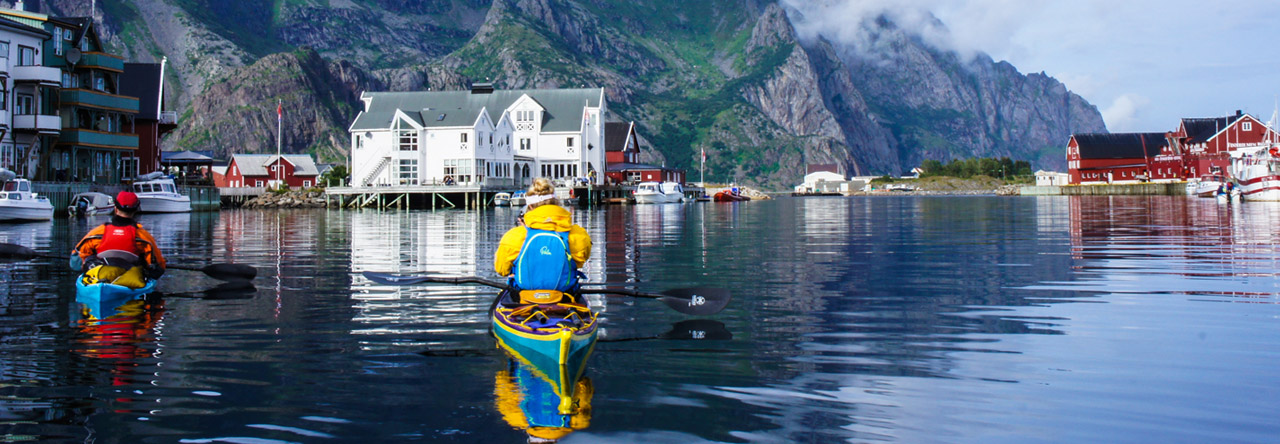
Distance: 2300 miles/3702 kilometres
Duration: 71 days
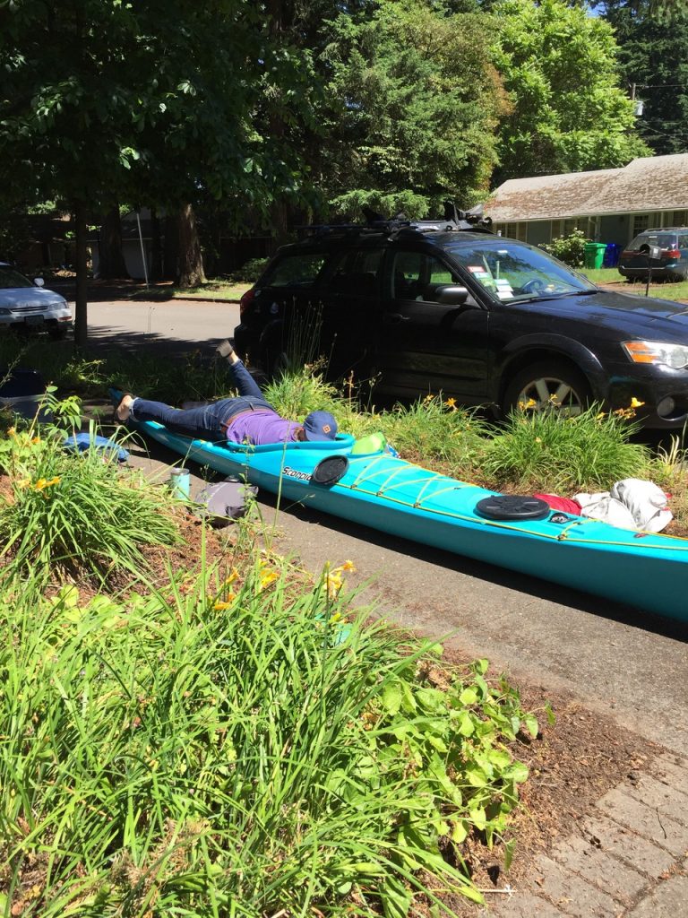
Kayak: P & H Scorpio 170
The 7 rivers 7 continents project is a multi-year undertaking to make paddling descents of the longest river on each continent. 22 000 miles in total:
Amazon River (South America) – 4125 miles – completed 2007/2008
Missouri- Mississippi River (North America) – 3780 miles – completed 2012
Volga River (Europe) – 2300 miles – completed 2014
Nile River (Africa) – 4132 miles
Yangtze River (Asia) – 3916 miles
Murray-Darling River (Australia) – 2904 miles
Onyx River (Antarctica) – 25 miles
My descent of the Volga River began around 400km north-west of Moscow following an intense 5 hour car journey from the capital. If you’ve ever driven in Russia, you know that breaking one’s speed PB is a requirement on every car journey.
The ultimate source of the river sits amongst the green, rolling Valdai Hills. Unlike the Amazon and Missouri-Mississippi River sources, access to the river’s beginning is a breeze. Marked by a small shrine, an imposing church and a scattering of houses, the source is easily reached. There is even a souvenir stall set up!

Like big rivers the world over, the Volga’s source is auspicious in it’s humble beginnings. A small pond-like body of water over which had been built the aforementioned shrine. Just a few weeks earlier it had been frozen over. As I set off the rain began in earnest. It was cold, bleak and once more I found myself alone in a strange land ready to undertake another big river descent.
The river’s drainage was contained in a small, marshy valley. I walked on it’s sides, across it’s middle and along its course. I had left my heavy, fully loaded P & H Scorpio kayak a few miles from the source. It sat in the front yard of a family’s house by the edge of a small lake.
A few hours in, thigh deep in very recently thawed ice water under a heavy grey sky is not great fun, but it is what it is, necessary. I burst out of the dense, wet forest on to the lake shore and made my way to the nearby village where my boat lay.
After being stuffed full with hot tea along with meat and pickle sandwiches, I bid farewell to my first river saviours and dragged my kayak down to the water’s edge. A brief repack and I was paddling. The clouds parted and the sun burst through with surprising intensity. Now it was really on.
The upper Volga, indeed the entire Volga is akin to one giant lake. A total of 9 dams choke the river and reduce it’s flow to a near standstill. No mean feat over a couple of thousand miles.
The first meandering lake is alternately populated by rustic, grey, Soviet-era (and much older) wooden house villages and enormous luxury holiday surely owned by that infamous character, the Russian oligarch. Homes styled with their own (totally unnecessary) lighthouses, pirate themed boat houses, marbled columns, Ibiza style gazebos and fire pits.

My first few days on the river were punctuated by bright sunshine and frigid blasting winds swapping with rainy squalls. My dry jacket, wool cap and thermals were put through their paces.
That first week, 2 weeks of a long journey are always the same. That period of adjustment from comfort, warmth and cleanliness, to, well, the opposite of all those things. To me, long kayak journeys, no matter the hardship are really just one big holiday, so I try not to complain too much (or at least out of earshot of anyone else). Life is simple. Stay dry, stay fed and watered, stay upright. It’s pretty straightforward.
The first dam, appearing below Selishche, is small and guarded by private security contractors. Their knuckles covered in tattoos, sporting old and rumpled uniforms and cigarettes hanging from mouths, I wasn’t sure what to expect. With a flourish of my official looking letter from my hosts, the Russian Geographical Society, well adorned in government stamps, the lads jumped into action. I was ready to pull my boat around the dam on my kayak cart but they indicated we, the 3 of us would carry it. A few hundred metres of struggling with my heavily laden kayak and I was back paddling, kind of. The first couple of kilometres below the dam was boney with little water. Knuckle dragging and actually dragging my way downstream was arduous. The river was just 20m across and wound its way this way and that through the dense pine forest.

With sun shining, the Volga was magical. With rain about slightly less so. I passed several groups of paddlers who had spent a long weekend kayaking on tributaries of the river. At the town of Staritsa I was keen to resupply with food. A couple of young boys on bicycles stared down at me from the high river bank. I asked them where a “magazin” or shop might be in my best Russian. Nothing. “Magazin?”, I repeated. Oh yes, over there somewhere, they waved. Not exactly reassuring. Just downstream was a huge steel bridge spanning the river. Below it on river right were a couple of trucks. Here, I thought I could leave my boat and head into town. As I approached I realised one of the old trucks was loaded down with about 10 kayaks! Sweet! A group of young Russians had just taken off the river after 4 days paddling the Volga and a tributary. I was immediately invited to join them for tea and food. Instead of allowing me to venture into town they began putting together bag loads of food for me. Cheese, sausage, bread, cookies, tea, spaghetti, tuna, corn, apples, pickles, milk and juice. Their trip was over and they were headed back to Moscow. Their kindness was amazing. As I paddled away, the clouds cleared and the sun shone.
After 8 days I reached the city of Tver. My first chance to upload some photos and write some articles for publication. I spent 2 nights in Tver, also resupplying and getting lost in my first Volga city.

After Tver I began to meet and visit with more and more people. Their welcome and kindness was hard to believe. I had not expected this sort of welcome. There are always nice folk on every journey but on the Volga it seemed everyone was smiling at me.
A few days later I reached the second dam at Dubna. This time a significant hydroelectric dam whose construction included a lock for ships. Entering (and leaving on river right) was the Moscow Canal. Had I so desired I could have paddled this waterway all the way to the centre of Moscow! But my destination lay a couple of thousand miles to the south.
I was met by a new friend at the portage. Ilya was a giant of a man who worked as a security guard at the dam. It was his day off and he and friends had celebrated his wife’s birthday the night before. Instead of loading my kayak on to my cart Ilya insisted we carry it. Oh man! It was heavy. I think both of us had some national pride helping us. Me the Australian and him the proud Russian. We took a few rest stops for Ilya to smoke a cigarette and share the vodka he kept in an army issue water bottle on his belt. After 5 breaks to reach the river once more I was feeling pretty relaxed! The first of many vodka battles on my journey.
Days continued unabated. Long hot days, long wet days, always punctuated by meeting people on the Volga. On resupply in larger towns or cities, someone was always more than happy to keep an eye on my kayak. In small villages it wasn’t necessary.
Russians love the Volga! On weekdays and weekends in particular, every day saw people camping, relaxing, fishing, swimming and boating. Even when I felt totally alone, around a bend I would see a cluster of tents and people about. It was great to see them making use of this giant river, not just for industry or commerce but for it’s true wildness.
I paddled on and on. Each dam portage took on average a hard hour. From landing on the concrete wall of the dam to putting in below I unpacked, did multiple carries, dragged my kayak trolley over busy train tracks, busy roads, through dry scrub, down steep hills, repack and away. From start to finish I pushed as hard as I could. Portages are never much fun.
Below each dam, there was actually some flow. It was a surreal feeling to have spent days and weeks on what amounted to one long lake to be suddenly carried along in a swift current.

In the city of Yaroslav I visited with the Russian emergency services group, EmerCom. They look after safety on the river for all users, from sunbathers, to fishermen in boats, to the cruise ships and tankers that were now becoming more common. On a Saturday afternoon, some of the younger members eagerly volunteered to patrol the packed beach with a pair of giant binoculars. Tough gig.
At every stop, I longed to stay. Just sitting, drinking tea, eating, laughing, talking with these people of the Volga was incredible. The Russians I had met were so full of life and so friendly. A start contrast to the brainwashing I had been given since birth of life behind the Iron Curtain, its dreariness and its underlying anger to the West.
A month into my descent of the Volga and it had surpassed everything I had hoped for. The beauty of the river, the welcome of its people was difficult to believe. But it just continued to get more amazing.
At the city of Kimensha I had been battling a headwind all day. I was a little over it. Just beyond the bridge that spanned the river I thought I could see a giant wooden raft. Could it be? As I paddled closer the raft revealed itself. It was a huge hybrid Kon-Tiki (the balsa raft built by Thor Hyerdhal to cross the Pacific) with a wooden body and three giant inflated PVC pontoons. Around it milled a dozen people. I had to explore this!

The raft was named, “Rus”, the old word for Russia. It was a boat for travelling the world! Piloted by just 3 crew it had been all over the Arctic, the Berents Sea, Greenland, Canada, Black Sea and of course the Volga. I was welcomed with tea, beer and a stew for lunch. A television crew arrived and I was honoured to help push the 3 tonne craft into the water and raise its mast. What a boat! I stayed the afternoon with the boatmen and as the sun was setting pushed off to paddle a couple of more hours downstream.
It was slowly becoming clear that the Russians of the Volga were not people to sit still. In just a few short weeks I had met ocean sailors, whitewater kayakers, parachutists and round the world cyclists all by the banks of the river.
My descent continued. The river grew wide and wild. Powerful winds whipped up breaking waves. They crashed on steep shores and on concrete embankments in front of towns, creating such confused water. I dared not miss a stroke or a brace or I would be wrong side up in an instant.
It felt strange to still think of the Volga as a river. It was so wide with huge bays and coves it could not be so. Late in the afternoon but still with plenty of light to paddle I chanced upon a group of kite surfers. High winds for me a nightmare, for them it was time to play. 10 kites jumped and sped across the water. As brothers in arms I stopped to say hello. Immediately dragged over to their camp I was fed a late lunch, vodka, tea, dried fish and beer. As luck would have it a few of them were headed to the shop in town. I took a ride with them and filled up on pasta, sugar, sardines and chocolate bars. Perfect.
Another dam, another portage over. For a while the water flowed, then as before slowly petered out. Flat water, still water to paddle. The large city of Nizhny Novgorod loomed ahead. From start to finish the urban centres on the Volga stretched for some way. With masses of tankers, cruise ships and small boats about it always took longer than expected to clear them. At Nizhny, the river Oka entered from river right, in the centre of town. As the slowest moving vessel, I played chicken with all the other boats. Jet skis roared by, expensive speed boats complete with bikini clad models, cut across in front of me. The city itself was clearly divided into ancient and modern. It’s impressive Kremlin dominated a green hillside, while in front and behind modern apartment buildings loomed. Almost past the city, a cable car stretched across the river. It took passengers on a scenic ride from Nizhny Novgorod to the smaller city of Bor on the left bank of the Volga. As I floated by I wished for more time to explore the city. Slowly, very slowly the days left on my visa had started to enter my mind.
Again, the river’s flow subsides and it’s banks move further and further apart. The Volga’s beauty continues. Where are the factories and industry spewing pollution into it’s waters? If they exist they are well hidden from view.
At the city of Cheboksary the sand river beaches are packed with sun bathers. Families, children, girls in bikinis, young toughs cruising in cars, old men deep in conversation with one another. More jet skis and fast boats zip this way and that. I stop at a concrete marina. Once more my friends at EmerCom lend a hand. I trudge up a steep hill to the shop for resupply. Dimitri, who works for the emergency services offers their quarters for me to stay. I am just a few miles from the dam and even though late in the day I would like to portage it. I thank him for the offer and put back in.
All my journeys suffer from a personality disorder. With 2 goals on every descent, source to sea and the gathering of images and stories from the river – it is supremely difficult to find a balance. Ensure the success of one and jeopardise the other. Turning down an invitation to stay the night, to talk, to drink in order to paddle some more always grates. But failing to reach the river’s mouth and the sea is finite. A difficult decision to make.
I am buoyed by the knowledge that approaching the huge city of Kazan I have a few days at least to reenergise, resupply and explore. I have friends in the city and eventually spend 4 days in hastily arranged press conferences, television appearances and sight seeing. I make new friends and find a city that captures my heart.

Some of the weather I have encountered on the river so far has been brutal. Storms which creep up from behind the low mountains which line the Volga and then unleash rain, wind, lightning and thunder have been both exciting and un-nerving. Multiple times i have completed big open water crossings with minutes to spare before the water is whipped up into a white foaming mass, waves breaking in every direction. Good assessment of conditions on my part or just luck?
Beyond Kazan, I spend 5 days battling this inclement weather. A couple of times, people stopped me and established that they had seen me on television. I was famous on this little part of river.
The river twisted and turned, the left bank disappeared from view as another might river, the Kama joined it. Wind blew hard from the west. The sheltered bank was almost entirely stark and steep cliffs. Hardy vegetation filled any small break in the rock. Finding a camp site as night rapidly approached became an unsettling task. I crossed to the other side, exposed to wind and waves but with more camping options.
Now the right bank vanished. The water stretched for almost 30 kilometres from side to side. As I high braced into overhead crashing waves and surfed sometimes down their open faces I wondered if perhaps I had erred in judgement. Too late now I pushed on.
At the city of Ulyanovsk as darkness set in I had resigned myself to a camp beside an old factory. Before I had a chance to make landfall a voice called out. A man waved to me from the bank. That night was not spent in a tent beside an old factory. I slept inside a Dacha or summer house. I also experienced my first Banya or Russian sauna complete with being flogged with birch branches and running naked into the Volga. Dinner was a huge event with new friends, talking about the Volga and the similarities between Russian and the West. The river, as usual, provided for me.

I left early in the morning after a bacon and egg breakfast and straight into a day of the hardest paddling of the entire descent so far. Weather reports suggested that the day was about to get pretty windy. From the edge of the city to the next point was 25 kilometres in a straight line of open water. Following the river bank would add another 10 kilometres on top. I had been through some difficult paddling in the week previous and felt up to most things the river could throw at me. The crossing turned into a 7 hour affair. Not once could I dare to miss a stroke or a brace. I fumbled when I could with a chocolate bar for energy. For 6.5 hours I needed to pee. No chance. Relieving myself in my boat was a serious consideration. As I collapsed on shore in mid-afternoon under a grey sky I swore never to make myself as vulnerable again. Then I took a pee.

The gods of the river must have decided that more than a week of rubbish weather was my penance paid. On an afternoon a few days after my less than fun crossing I nudged my boat onto a wide and long rocky beach, the water crystal clear below me. The entire day had been almost without a breath of wind, the scenery out of this world. Low rolling hills, dotted with groves of trees, small villages here and there. Now a dry camp with the huge expanse of the Volga in front of me. These moments more than outweighed the days of rain and wind.
From the Tolyatti dam to the city of Samara, the river continues it’s brilliance. In one day I saw hundreds of sail boats and catamarans, kite surfers, paragliders, mountain bikers, campers, fisherman and people just making the most of the resource they had on their doorstep, the wonderful Volga. It was amazing to witness. At Samara the city lines river left. On river right opposite hundreds upon hundreds of semi-permanent encampments exist. Come the weekend thousands of Samara citizens cross the river in taxi boats, bus boats or their own boats to spend a couple of days relaxing and often partying. I struggled to find an empty spot to erect my own little camp. I eventually did and set to work on my tent. As I finished it a couple of young Russians walked by and said hello. I replied in Russian and of course they immediately knew I wasn’t one of their own. Upon hearing I was an Australian paddling the length of the Volga River they literally dragged me back to their party camp. The World Cup was showing on a tv, speakers blasted Russian electronica (all powered by a generator) and the vodka flowed. I spent the night dancing, singing, laughing and talking with yet more beautiful people of the Volga. By now the welcome I had received on my descent was becoming surreal. How could it always be so amazing? How could every single person I met be so friendly? On all my travels I had not experienced such a thing.
I left Samara early the next morning trying to convince myself I had no hangover after the previous night’s festivities. It kind of worked.
At the city of Syzran the river makes a sharp turn to the south. It’s inside bend a maze of wetlands and small islands. Rather than stay on the wide open river I paddled into this confusing paradise. Birds called and fisherman sat bobbing about in their boats. Signs indicated that at least part of this area was a protected zone for birdlife. The area was more wild than other parts I had paddled through. The trees, vines and bushes were reluctant to ever part in order to expose even a small place to camp. Fortunately I discovered a fishing camp on an island. Deserted but well maintained with even the grass mowed.

Another dam at Balakovo. Portage takes 80 minutes with hauling over multiple railways tracks, through scrub and mud to pop up beside the dam’s guard post. I drag my kayak up behind a security officer toting a machine pistol and his civilian buddy. They haven’t spotted me and I have to announce my presence. I attempt to allay their confused looks with my by now pretty polished Russian language explanation of my journey. I also present my letter of introduction from the Russian Geographical Society. It has become my “magic letter”. It’s air of authority and liberal covering of government stamps works wonders. The guard steps out onto the busy road which crosses the dam and waves his baton. Cars speeding in both directions come to a halt and he motions me across. I thank him and wave somewhat embarrassed to the motorists who have stopped to let me cross.
A couple of days later I am passing the city of Saratov. Again it’s a weekend and the river is alive with people. Unfortunately the 2 windiest days of my entire journey so far are forecast. Even tracking down small side channels offers little respite. I just grind out the miles. A boardwalk in front of the city hosts a skate competition, small beaches are full with taxi boats ferrying people to and from small islands and camps away from the city. I resupply at a shop and chow down on crisps and fizzy drink. The wind continues to send the river into a fit. Waves push my boat from all directions. It’s hard work to stay upright and all this with an audience of hundreds.
On these days I paddle hard under a perfect blue sky, the river lined with houses perched on rocky cliffs. More invites accepted, more food offered and vodka consumed. This descent, hard at times really is a dream paddle.
For the next few days the river is straight and wide. Hours and hours of paddling every day and at times it feels like I am on a treadmill. The high banks like cliffs change little. Stopping to resupply is a welcome change. I stop in an ancient village where 9 out of 10 crumbling wooden houses seem deserted. Searching for water, I occasionally spot a babushka (grandmother) down a side street. The village has a bunch of wells lining the main street. Most are not functioning. One thankfully, is. I arrive to the well at the same time as an old lady with her own water bucket to fill. I ask for her to go first but she won’t have it. Embarrassingly, I need her help to control the water flow. We chat about the Volga in Russian and walk together back down the road.

In the meantime back down by my boat, a group of 6 men have landed in their fancy speedboat and commenced a mid-week BBQ. With 7 hours of the paddling day left, I was expecting some big mileage. Not to be. I ate my fill of meat, bread, vegetables and unfortunately drank my fill of vodka too. A highlight was all of us jumping in the boat and speeding out into the middle of the Volga, at this point 3 miles wide. Under a clear sky, I spent the next hour jumping from the boat into the cool waters of the river miles from land. An unforgettable experience.
Late in the afternoon I was finally able to extract myself from my new friends. After an hour and a half of slow, vodka affected paddling I decided to call it a day. What a day.
Volgograd in sight. The 9th and final dam separates me from this city where in WWII, the Battle of Stalingrad cost some 2 million lives. A difficult 1 hour and 15 minutes of lifting, dragging and pulling sees me put back in on the Volga. After failing to get any sense from a boat crew who are well past simply drunk I spend the night on a floating cafe with my new Armenian brothers. I am welcomed aboard with huge smiles and as usual stuffed full of food and vodka! We talk, dance, laugh and swim late into the night and some of the morning.
A day or two below Volgograd the river is still moving. Not atypical for a river usually but on the Volga a pleasant surprise.
Villages that touch the river become less frequent, as briefly do the number of fisherman and river users. For two consecutive days I am trapped in the open when huge electrical storms hit the river. I can see small towns in the distance high atop sheer cliffs. Creeping up behind then and headed my way, enormous black cloud mass, lit by lightning in quick succession. As the storms hit with a harsh mix of rain, wind and electricity it is hard not to duck lower in my cockpit. As if that might make me a less appealing target. Each time I push on and in between squalls find good camps on huge river islands. Sometimes with neighbours, often alone.
I make camp above the city of Astrakhan one beautiful Saturday afternoon. The entire day I spend talking and waving with Russians playing by the river. Sometimes entire beaches are packed with swimmers and campers. A jet ski here and there, boats too. It is a real party atmosphere.

My final push to the Caspian sees me in a quandary. To enter the delta region all visitors must hold an authorisation from the FSB (the modern day KGB). I have the authorisation. Applied for 60 days earlier and granted a month ago. Unfortunately the FSB office is only open for business Monday to Friday, not the weekend. Should I wait till Monday, another day and a half to get a hold of my document or make a break for the prize? In the days above Astrakhan I had heard stories that taking the main channel to the sea was forbidden, permit or not. Heading down there without having my authorisation in hand seemed like asking for trouble.
As the sun dipped below the horizon, the Volga was lit up in gold. I ate my dinner of pasta and sardines looking out over the river, trying to decide what to do. It would be a massive blow to get within a few miles of my goal and be picked up by the authorities for some sort of infringement. I looked over the paperwork I used the apply for my permit. I had listed the exact towns and villages through which I would pass on my way to the Caspian. The all lay on the main channel. How could there be a problem? I decided right then to go for it.
Another city to clear. The wind was blowing hard, the river wide and boat traffic was everywhere. Just below Astrakhan, small beaches lined the banks. Once again it was a full party atmosphere on the river. Windsurfers whipped back and forth across the river dodging huge ships, water police were busy inspecting recreational boats for life jackets and registration.
Invitations to join BBQs and parties came along steadily. I stopped over the day now and then to say hello before moving on, a smile permanently etched on my face. As I had done over the past couple of months of paddling I shook my head in wonder at the welcome I had received in Russia. It was almost too much.
With the river still flowing reasonably strong, channels began branching off on river left. The delta was growing wider and wider. Thousands of small channels now snaked their way to the sea. My route left me on the main channel heading south west. At times less than 100m across I shared the waterway with petrol tankers and the like.
My final evening on the Volga was low key. I pulled out at a small boatyard and jetty. Two rustic houses amongst recently mown grass. Still in PFD and paddling gear I wandered up to the smaller of the two. Inside was Alek, a big bear of a man who oversaw the place. Gruff at first, once I explained my presence he was pleased to have me camp by the river on his place. Another glorious sunset came and went. How many of these have I been fortunate to witness on my big river descents? Hundreds, surely.

On the water by 7am the next day I couldn’t help but wonder when around the corner would come a navy patrol boat to end my journey. I continued to pass small villages on huge delta islands, connected to the mainland by a short ferry ride. In a couple sat massive navy ships at anchor, sailors working on board. Did they see me? I was getting more paranoid the closer I go to reaching the Caspian Sea.
Now the main channel I was on became ram rod straight, at it’s end lay the sea. Indeed now on either side of this man made stretch lay the Caspian, reached by even narrower channels. On my maps the area should have been deserted but still I would see old abandoned fish processing factories, crumbling houses and light poles.
One house, half fallen into the water already looked empty. A large dog appeared, then an old man, followed by one younger. I paddled over to them and chatted a while. They were living deep in the delta, miles from any town in a house only barely there. They seemed to be among the happiest people one could ever meet and pointed out the next turn I should make to reach the small town of Vyshka where my journey would end.
After a confusing maze of tiny waterways and thick jungle like vegetation all of a sudden I paddled out into open water. Was this the sea? There was some islands a mile south of me but excepting them it was indeed the Caspian. A half mile to my right I could make out the town of Vyshka. A name and spot on a map of which I had dreamt for many months. I slowly paddled toward it.

After some 2300 miles and 71 days I had kayaked the Volga River, Europe’s longest river from source to sea. I had paddled a river so beautiful that it was almost unreal. Picturesque lakes, pine forest, rolling hills, rocky cliffs, open dusty steppes, huge cities and small villages. It was stunning. But what really had made my descent one so special were the people of the Volga. From beginning to end the Russian people had welcomed me, cared for me and extended a hospitality I had never expected as a stranger. As I neared my final takeout I was genuinely sad to be finished. My time on the Volga River was over, it was time to go home.